EarthRanger is the conservation technology platform that UWA uses to monitor, protect, and manage wildlife in real time within protected areas.
By Willy Chowoo
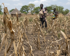
Nwoya District
For Opiro Francis, it seemed like business as usual—slipping into Murchison Falls National Park to carry out illegal hunting undetected.
What he did not realise was that the park was no longer relying solely on traditional patrols. Something they have eluded for a long time.
Behind the scenes, digital surveillance powered by EarthRanger was quietly tracking movements—both of wildlife and suspected criminals.
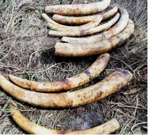
His luck ran out on 22nd February, 2026, when he was intercepted with 154 kilograms of raw elephant ivory, in what authorities describe as a targeted, intelligence-led operation.
The crackdown was spearheaded by the Uganda Wildlife Authority’s Special Wildlife Crime Unit, working closely with the Uganda Police Force.
The arrest underscores a growing shift in Uganda’s conservation strategy—where technology-driven intelligence is replacing guesswork, making it increasingly difficult for poachers to operate unnoticed.
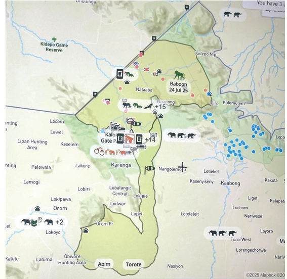
In places like Murchison Falls, Queen Elizabeth, and Kidepo Valley Conservation Areas, the first installations of the technology have marked a turning point in Uganda’s anti-poaching strategy.
Rangers now track elephants via satellite collars, monitor patrol rates in real time, and respond instantly to threats inside the protected areas, as in the case of Opiro.
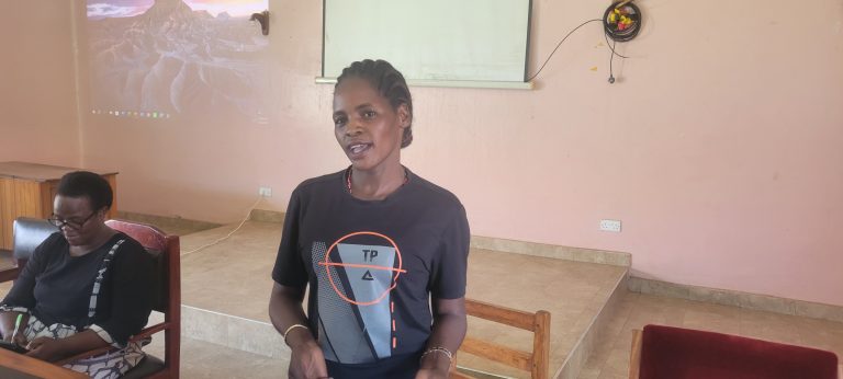
Turyatemna Mavodi, Warden in charge of Law Enforcement at the Murchison Falls Conservation Area (MFCA), says the new system provides precise coordinates of suspects and can capture real-time photographs.
“It helps us to show how many people are passing and which weapons they have; it has increased our success rate; we have seen poaching going down,” he adds.
What is EarthRanger?
EarthRanger was donated to the Uganda Wildlife Authority (UWA) by the Allen Institute for Artificial Intelligence (AI2), in collaboration with the Uganda Conservation Foundation and the CITES Monitoring the Illegal Killing of Elephants (MIKE) Programme.
It is a conservation technology platform that UWA uses to monitor, protect, and manage wildlife in real time within protected areas.
This presents part of UWA’s broader digital strategy to strengthen anti-poaching operations, improve patrol effectiveness, and respond quickly to wildlife threats.
At Murchison Falls Conservation Area, the authority uses this seamless technology to detect illegal entry into the park and provide real-time locations of poachers.
The system, which was introduced in 2022, has been useful in fighting illegal wildlife trade inside the park
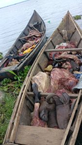
Earlier, on 19th October, 2025, UWA rangers arrested two illegal poachers from the Delta Marine Post in the Kafundo area of Murchison Falls National Park who were transporting buffalo meat in two canoes.
They were tracked using the system. From 2022 to 2024, the park authority has registered an increase in the number of illegal poachings inside the park. There were 2,257 suspects arrested over those periods.
And in 2024, they arrested 945 suspects compared to 2022 when they arrested 617. The statistic below shows an increase in the number of arrests.
This shows how the use of innovative technology such as EarthRanger has increased the surveillance in the protected area.
Murchison Falls NP is the largest park in the country with the highest number of wildlife crimes in the country.
Inside the Murchison Falls EarthRanger Laboratory.
A team of experts sits intently before a large wall-mounted screen, tracking alerts in real time, analysing data, and coordinating closely with patrol rangers in the field.
Mavodi adds that they use the system to monitor whatever is happening in the conservation areas in real time.
“We use a graphic system to trace our roads; at the end of the day, you use that map to show where there is a lot of concentration,” Mavodi adds, “where movement has been so much, and that becomes hotspots, and we can keep monitoring them.”
Using the system has made deployment of the patrol ranger very simple, as they monitor illegal activity from the lab, and the field team is guided accordingly.
The system alerts illegal activities within the protected areas, enabling rangers to respond to such activities. For example, the arrest of Opio with the ivory.
“You just tell your team to go there; you will be able to coordinate how they are moving and where they have reached,” Mavodi notes.
The EarthRanger also provides scientific evidence; the patrol rangers take real-time pictures of the suspects arrested and feed them into the system that has coordinates.
“The patrol rangers usually take coordinates of the places where a suspect is arrested and their photos, which are uploaded to the system in real time.”
Mavodi maintains. Mavodi explained that the technology has strengthened their ability to present solid, well-documented evidence against arrested suspects in court, since all information is now digitally recorded.
This helps the authority to provide scientific evidence in the prosecution of the suspects arrested to secure successful convictions. The use of EarthRanger to adduce evidence has already been tested in the prosecution of suspects in the court.
In February 2026, one of the UWA rangers, Gift Kusemererwa, attached to Murchison Falls NP, used evidence gathered from EarthRanger to place the five suspects at the scenes of the crimes they committed in the park.
They were accused of killing a young elephant, illegally entering protected areas, and transferring a protected wildlife specimen. The Wildlife Resource Report, 2026, highlighted the successful use of the EarthRanger system has improved decision-making in conservation management.
For example, out of 2257 suspects arrested from Murchison Falls NP, 1228 were convicted between FY 2021/2022 and 2023/2024. This represented a successful conviction rate of 54.4%.
While reacting to the report, UWA Executive Director Dr. James Musinguzi said this demonstrates Uganda’s steady transition toward science-led and technology-assisted biodiversity management.
The technology-assisted biodiversity management is being done through aerial wildlife surveys, SMART ranger patrol systems, EarthRanger collar monitoring, camera trapping, digital ecological databases, and expanded ecosystem monitoring.
At Murchison Falls Conservation Area (MFCA), illegal poaching remains a significant threat to wildlife conservation. But the system’s presence is registering success.
The park has recorded a reduction in illegal poaching cases over the last 3 years. They attribute the reduction to continued intensive anti-poaching operations across the protected areas.
The park authority registered an increase in recoveries, from 6,615 in 2021 to 12,245 in 2024, an addition of 5,630 items, representing an 85.1% increase.
These efforts have also resulted in 617 arrests in 2022, 695 in 2023, and 945 in 2024.
UWA intends to use technology innovation as one of the core activities in their new five-year strategic plan, where they intend to upgrade their anti-poaching and conservation management efforts by integrating drones, GIS, and forensic science.
The UWA Assistant Commissioner for Communications, Hangi Bashir, said EarthRanger is the future of wildlife conservation in Uganda. “With GPS tracking, we don’t just react to threats—we prevent them; we can detect movement patterns, identify risks early, and respond in real time,” Hangi adds.
“When an unusual movement is detected—such as elephants straying into high-risk areas or suspicious human activity—alerts are triggered instantly,” notes Kizza.
This allows rangers to respond quickly to poaching threats, intercept illegal wildlife traffickers, and prevent escalation of human-wildlife conflict.
Tracking Elephants Across Borders.
The Uganda Wildlife Authority has continued to respond to cases of human-wildlife conflict across the protected areas.
There were 20,837 cases reported between 2020 and 2022. However, elephants are the leading cause of human-wildlife conflict (HWC) around Uganda’s conservation areas.
For instance, between July 22 and June 2023, there were 6,999 cases of HWC reported across the country, according to the UWA annual performance report 2022.
Of these, Elephants contributed 2890 cases of human-wildlife conflict in communities neighbouring the national parks, followed by buffaloes (319) and hippopotamuses (214). This is 41.2% of the total case.
With the introduction of the EarthRanger, the system is helping to track elephant movements, offering real-time responses by the park authority.
EarthRanger plays a critical role in monitoring and tracking elephant movements through a combination of real-time data collection, geospatial analysis, and coordinated ranger response.
In landscapes such as Kidepo Valley National Park and Murchison Falls National Park, elephants fitted with GPS collars are continuously monitored.
The park authority uses the data to detect increased transboundary movement of elephants, shifting migration routes due to climate and habitat pressure, and entry of elephants into community areas.
As of 2023–2025, Uganda’s elephant population is estimated at 6,352 individuals, compared to 6,621 recorded in 2021–2023.
The decline highlights ongoing migration into neighbouring countries; the occupation of community areas in Karamoja, where they are not counted in surveys; and limited poaching.
For the elephants that are already there, the park authority has been using the EarthRanger to track their migration into Kenya.
UWA ED Dr. Musinguzi says the movements show the need for regional cooperation matters.
“EarthRanger data for elephants show a widespread transboundary movement into neighbouring countries due to natural migratory behaviour and landscape-level ecological dynamics.” Dr. Musinguzi highlights.
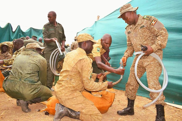
At Murchison Falls National Park alone, more than 200 animals have been collared. It helps them to monitor if the elephants are going beyond their ranges.
This helps the park authority to identify when elephants are approaching human settlements. This information is critical not only for conservation but also for early warning systems for at-risk communities.
According to park authorities, only one animal per herd is fitted with a GPS collar.
However, the uncollared animals are often involved in human-wildlife conflicts. “We closely monitor the movements of collared animals and promptly alert our rangers if they begin to stray beyond designated areas,” notes Kizza.
The park authority explained that the elephants are fitted with GPS satellite collars that continuously transmit their location.
These collars send real-time movement data to the EarthRanger platform. The teams use it to monitor elephant migration routes, detect unusual or sudden changes in movement, and track herd behaviour across landscapes.

This system displays elephant locations on live maps and overlays movement data with protected areas, communities, and risk zones. This enabled the Uganda Wildlife Authority to protect elephants, reduce human-wildlife conflict, and make informed conservation decisions based on real-time and historical data.
UWA plans to enhance the use of GPS and satellite collaring of wide-ranging and conflict-prone species, which will provide better insights into movement patterns and support early warning mechanisms and landscape planning.
Bridging Technology and Communities.
Beyond enforcement, EarthRanger is helping bridge the gap between conservation authorities and local communities.
With innovation that can predict wildlife movement, UWA is using it to warn communities about approaching elephants, which is helping to reduce crop destruction.
Kizzaa says they also face occasional resistance from communities who may not fully understand the role of these technologies. But through continued sensitisation, partnerships, and capacity building, they are changing the perception.
“We are working to overcome these obstacles and ensure these tools serve both conservation and community needs.” He adds.
The technology is also helping UWA plan mitigation strategies, such as fencing and deterrents, in the elephant’s hotspot areas at Murchison Falls NP, including Got Apwoyo and Purongo sub-counties in Nwoya District.
There has been a reported reduction in cases of elephant intrusions in these areas due to the erection of an electric fence, according to local leaders.
Justine Okot Ajagi, the LCIII chairperson of Lii, one of the sub-counties neighbouring Murchison Falls NP, can attest to this: “We have, in areas where there is an electric fence, fewer cases of elephant intrusion compared to those without it.”
This is particularly important in areas surrounding protected zones, where human-wildlife conflict is rising.
The executive director emphasized during the launch of the new strategic plan that they plan to enhance collaboration with neighbouring communities, “ensuring that residents around protected areas benefit from conservation activities while helping safeguard Uganda’s heritage.” He adds.
Communities neighbouring the protected areas who directly benefited from the contribution to community livelihoods (revenue sharing).
For example, UWA has given Sh13.4 billion to the districts bordering Murchison Falls NP between 2019 and 2024. The districts are Nwoya, Masindi, Kiryandongo, Buliisa, Oyam, and Pakwach.
This is to empower the community to play an essential role in wildlife conservation.
A Model for the Future.
The Uganda Wildlife Authority has continued to achieve successes while curbing wildlife crimes in the protected areas. Over the past five years, the authority has conducted 114,000 anti-poaching patrols, resulting in the recovery of 156,823 poaching implements and the arrest of 11,597 suspects.
Among the recoveries made between 2021 and 2022, there were 2410 kgs of elephant ivory, 1,901 kgs of pangolin scales, 688 kgs of hippopotamus teeth, and 12,155.4 kgs of game meats. This success is attributed to the deployment of technology-led surveillance.
Assistant Commissioner for Conservation Planning, Richard Kapere, said these operations have significantly strengthened wildlife protection and reinforced Uganda’s commitment to combating poaching and illegal wildlife trade (IWT)
The Wildlife Report 2026 highlights issues such as limited coverage in some remote areas, even with these challenges. Despite this, Mr. Kizza emphasises that although most of these technologies rely on internet connectivity, they remain committed to their adoption.
“As a government, we are ready—we are embracing technology to enhance our conservation efforts and help sustain natural habitats,” Kizza added.
The use of real-time data, field intelligence, and advanced mapping has demonstrated its effectiveness in reducing wildlife crimes within protected areas. Uganda is building a smarter, more responsive wildlife protection system.
“As technology continues to evolve, we are committed to adopting innovations that strengthen our ability to conserve wildlife effectively,” Bashir notes.
For a country rich in biodiversity but facing increasing environmental pressure, this innovation could be the key to safeguarding its wildlife heritage.
Scaling Up Technology.
The UWA’s new ambitious five-year strategic plan (2026-2031) focuses on a more technology-driven approach to wildlife conservation and tourism development.
Dr. Musinguzi says the authority has continued to deploy modern technology to enhance wildlife protection and conservation management.
“The new strategic plan will leverage technology—including drones, forensic services, GIS, and digital systems—to strengthen anti-poaching efforts, improve wildlife protection, and enhance conservation management.” He notes.
While Uganda has successfully pioneered the use of digital solutions for wildlife monitoring, wildlife crime is also becoming more sophisticated, so conservation scientists are appealing for efforts to evolve just as quickly.
Bashir states that despite successes in curbing threats to wildlife, poachers are becoming increasingly sophisticated, making it insufficient to rely solely on foot patrols or community reports.
“Technology complements traditional conservation methods by making monitoring faster, more efficient, and proactive rather than reactive,” he emphasises.
To address this challenge, UWA intends to scale up technology for effective wildlife monitoring across Uganda’s protected areas and wildlife landscapes.
UWA plans to increase the usage of AI-enabled camera trap analysis, drones, and advanced satellite imagery collection for detecting wildlife habitat change, encroachment, and illegal activities.
“We are just getting started,” says Hangi. “In the future, we plan to introduce AI-powered tracking and expand real-time monitoring across all parks.”
With a plan to deploy more EarthRanger technology to other protected areas, Uganda is proving that technology can play a critical role in protecting endangered species, not just by reacting to threats but by anticipating them.